Be Part of the Pooler Change
One (1) Active DRIs
There is one (1) Active DRI
The city of Pooler, Georgia has been reported for not doing DRIs for projects that change the trajectory of the city and adversely impact the natural habitats, wetlands, biodiversity and history of our community.
DRI 4732
#4732 - Harmony Subdivision Phase 9
Pooler (WARDLAW Family)
At the end of Andante Way
Plot: 51010 01046)
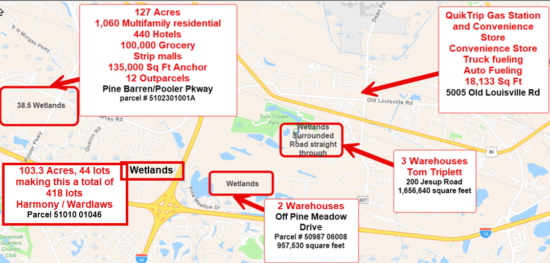
The site encompasses approximately 103.003 acres and is currently zoned Planned Unit Development. The developer is requesting 44 proposed housing lots. This would bring the total of 418 lots in the past five (5) years. The developer is requesting a Site Plan Development approval.
Please submit comments to fight this build on the wetlands by May 25, 2026, to planning@CRC.ga.gov
There is also a
Capital Improvement Plan
(CIE) open with the Coastal Regional Commission
Public Hearing Date: May 21, 2026, 10:00 am to 12:00 pm
Location: Coastal Regional Commission
1181 Coastal Drive SW, Darien, GA 31305
Return Comments to: planning@crc.ga.gov
Comment Deadline: May 29, 2026
Time to Get Involved
It is time for the community to step up and stop the further destruction of our community with warehouses, strip malls, hotels, multifamily rentals, apartments and unnecessary builds that are destroying our homes.
Please speak out against the projects at planning@crc.ga.gov
Review the open DRIs and Past DRIs at
https://apps.dca.ga.gov/DRI/Submissions.aspx
MAP OF DRIs Below
Tom Triplett and The District DRIs down the page
What is a DRI
Developments of Regional Impact (DRIs) are large-scale developments that are likely to have regional effects beyond the local government jurisdiction in which they are located.
The Georgia Planning Act of 1989 authorized the Department of Community Affairs (DCA) to establish procedures for review of these large-scale projects. These procedures are designed to improve communication between affected governments and to provide a means of revealing and assessing potential impacts of large-scale developments before conflicts relating to them arise. At the same time, local government autonomy is preserved since the host government maintains the authority to make the final decision on whether a proposed development will or will not go forward.
FACTS
Map Locations and Details
Harmony Partners
Pooler - Capital Improvement Element (CIE)
Concerns & Info
Development of Regional Impact
Public Comment Notice
#4732 - Harmony Subdivision Phase 9 - Pooler
Location: At the end of Andante Way, Pooler
(parcel
51010 01046)
PLEASE SUBMIT COMMENTS OPPOSING THIS BUILD IN THE WETLANDS May 11th thru May 25, 2026
Development Type:
Housing
The site encompasses approximately 103.003 acres and is currently zoned Planned Unit Development. The developer is requesting to develop the parcel as Phase 9 of an existing subdivision with 44 proposed housing lots. This would bring a total of 418 lots in the past 5 years.
The developer is requesting a Site Development Plan approval.
Economic Development
The estimated value of the project at full build-out is approximately $17,600,000. Upon completion, the proposed development is expected to generate an estimated $3,500 in annual local tax revenue. There are no full-time employees required for this development, and according to the applicant, the regional workforce is sufficient to fill the demand for this development. This development will not displace any existing uses and employees.
Water Supply
The City of Pooler will provide water service for the proposed development. The project is expected to generate an estimated water demand of 0.0132 million gallons per day. According to the applicant, there is sufficient water supply capacity to serve the proposed project, and a water line extension will not be required.
Wastewater Disposal
The City of Pooler will provide wastewater treatment for the proposed development. The estimated sewage flow from the project is anticipated to be 0.0132 million gallons per day. The applicant indicates that sufficient wastewater treatment capacity is currently available, and a sewer line extension will not be required.
Transportation
A traffic study has not been completed for the proposed development, and the applicant has indicated that no transportation improvements will be needed to serve this project. The applicant indicates the traffic volume per day expected to be generated by this development will be a minimum of 44 vehicles (one per home).
Solid Waste Disposal
The applicant stated that 157 tons of solid waste will be generated annually after completion of construction. The applicant indicated that the current landfill capacity is sufficient to serve the project and that hazardous waste will not be generated.
Energy Supply
The energy supply for the proposed development will be provided by Georgia Power. According to the applicant, the project's estimated peak connected electrical load per home will be 7 kilowatts, or 0.007 megawatts of power at peak hour. There are 44 lots in this phase. The applicant has indicated that sufficient energy supply capacity will be available to serve the proposed project. No additional infrastructure or on-site enhancements are anticipated at this time.
Stormwater Management
Approximately 20% of the project site is expected to be covered by impervious surface upon completion. Stormwater management ponds are proposed to mitigate the impacts of stormwater management.
Environmental Quality
The applicant indicates that the development is located within a wetland area.
Local Planning Considerations
The Future Land Use Map identifies the site within the Residential land use categories. According to the adopted local comprehensive plan, this district is established predominantly to provide land for single-family, multi-family, townhomes, condominiums, manufactured homes, and manufactured home park district dwelling units organized into general categories of net densities.
Adjacent DRI Activity
The DRI Map shows that in the last five years, there have been 10 DRI reviews in the surrounding area. With an additional 3 DRI reviews currently in process.
Regional Planning Considerations
Future Development Map designates the project site as Developing with a small sliver on the east side, next to the Savannah and Ogeechee Canal, to be Rural. Developing areas are expected to urbanize and require provision of new urban services. Rural areas are characterized by sparsely developed non-urban areas where land is primarily used for very low density residential or open spaces. These services will include water and sewer service at a minimum.
Areas Requiring Special Attention (ARSA) Map indicates that the project area is mostly within the Areas of Rapid Development with a small sliver on the east side to be an Area of Significant Natural Resources. This area is located next to the Savannah and Ogeechee Canal.
Green Infrastructure Map indicates the parcel has no green infrastructure identified. The Wetlands Map shows the southern area and small sliver on the east side of the parcel as Freshwater Forested/Shrub Wetland.
Flood Zone Map shows that the parcel is not located within a flood zone considered part of the special flood hazard area (SFHA).
Additional details on this development are available in the information forms linked here and here.
Please submit your comments by May 25, 2026, to planning@crc.ga.gov.
Sincerely,
Coastal Regional Commission
Planning Department
The City of Pooler New CIE - Updated Public Hearing Date
On April 22, 2026, The City of Pooler, Georgia, submitted a draft Capital Improvement Element (CIE) Plan to the Coastal Regional Commission for transmittal to the Department of Community Affairs (DCA) for review. Concurrently, Regional Commissions are required to conduct a regional review for internal consistency. The purpose of this communication is to describe the general nature of the draft CIE and notify interested parties that the draft CIE is available for review and comment.
The City of Pooler has developed a draft CIE to establish where and when certain new capital facilities are planned and the extent they may be financed through an impact fee program. The draft CIE addresses the following infrastructure categories: Fire, Police, Parks & Recreation, and Streets.
Public comment will be received by email through May 29, 2026. A public hearing will be held on May 21, 2026, from 10:00 am to 12:00 pm, to allow interested parties to provide public comment on the proposed CIE (see details below).
To review the draft CIE, please visit
Public Hearing Date: May 21, 2026, 10:00 am to 12:00 pm
Location: Coastal Regional Commission
1181 Coastal Drive SW, Darien, GA 31305
Return Comments to: planning@crc.ga.gov
Comment Deadline: May 29, 2026
If you have any questions regarding the CIE process, please contact us.
To learn more about CIE's visit Capital Improvement Element
Sincerely,
Coastal Regional Commission
Planning & Government Services Department
Coastal Regional Commission 1181 Coastal Drive SW, Darien, GA 31305 https://www.coastalrc.ga.gov/